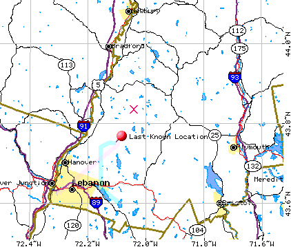
 This is a map from the now-defunct "Missing Learjet" website that shows the last
known position. I added an "X" approximately where the plane was
eventually found. There were 40-60 knot winds at 4000' from the southwest
that day.
This is a map from the now-defunct "Missing Learjet" website that shows the last
known position. I added an "X" approximately where the plane was
eventually found. There were 40-60 knot winds at 4000' from the southwest
that day.The missing Lear Jet
I still remember hearing about this crash on the local news, and I remember what a lousy day it was. I helped in some of the subsequent searches. It was a great local mystery for a long time. Wild theories abounded, including one paper's hints that maybe the pilots had absconded to another country. But the plane was eventually found, quite by accident.
Here's one article about the find, followed by more info I have assembled:
By The Associated Press Nov 13, 1999
WENTWORTH, N.H. (AP) -- The wreckage of a Learjet missing for nearly three
years has been found in a remote area, ending a mystery that far outlasted
the rain and fog into which the plane vanished Christmas Eve 1996.
The plane and two pilots disappeared after a failed approach to the Lebanon,
N.H., airport. That Christmas morning, planes, helicopters and hikers began
what would become the largest search in state history.
The official search was called off in early 1997 because of winter, but
volunteers continued to look.
In July, teams from New York, Massachusetts and New Hampshire spent 10 days
searching 3,452-foot Carr Mountain in Warren and Wentworth. The area was
suggested by a group of Dartmouth College engineering students who analyzed
the case.
A forester found the wreckage Thursday while surveying remote, private land
in Wentworth, said Fish and Game Col. Ron Alie. The land's owner informed
officials Friday of the discovery.
Family members identified the plane by a registration number on an intact
piece of wreckage and by clothing found at the site, Alie said.
``I'm not an investigator or anything, but from what I could tell they
really didn't know what hit them. It was basically a debris field. It seemed
quite instantaneous,'' said Jay Hayes, the pilot's brother, who saw what was
left of the jet.
The wreckage was found in steep, thickly forested terrain that lies within
the original search area, Alie said. He did not know whether bodies had been
found.
Wentworth, population 664, is about 23 miles northeast of Lebanon.
The pilots, Johan Schwartz, 31, of Westport, Conn., and Patrick Hayes, 30,
of Clinton, Conn., were en route from Bridgeport, Conn., to pick up a New
Hampshire family for a holiday trip when the plane disappeared during a
second runway approach.
Hayes' mother, Hermance, said New Hampshire officials contacted her son,
Jay, who has led many of the searches, about their find. From her
Connecticut home, she said the discovery was ``like starting a fire all over
again, like Day 1,'' but provided some measure of peace.
``In a way, yes, knowing that finally it came to an end, and not wondering
day after day, day after day: Where are you? Where are you, Where can you
be?'' she said.
Mary Marsh, a social worker and emergency medical technician from Worcester,
Mass., who helped search for the plane in September and last year, expressed
relief for the sake of the families.
``I'm so happy they found it,'' she said Friday. ``The poor families, it had
to have been such an agonizing three years for them.''
Despite the frustration, searchers didn't give up hope, she said.
``We do it because there's a need to do it and we want to bring back the
people for their loved ones,'' she said.
HERE IS THE NTSB FINAL NARRATIVE REPORT ON THE CRASH
NYC97FA194NYC97FA194
HISTORY OF FLIGHT
On December 24, 1996, at 1005 Eastern Standard Time, a Learjet 35A, N388LS,
operated by Aircraft Charter Group Inc., was destroyed when it impacted
terrain near Dorchester, New Hampshire. At the time of the accident, the
airplane was in instrument meteorological conditions, conducting an
instrument approach to the Lebanon Municipal Airport (LEB), Lebanon, New
Hampshire. The captain and the first officer, both of whom were certificated
airline transport pilots, were
fatally injured. An instrument flight rules flight plan had been filed for
the flight, from Igor I. Sikorsky Memorial Airport (BDR), Bridgeport,
Connecticut, to Lebanon. The positioning flight was conducted under 14 CFR
Part 91.
A sequence of events was derived from Boston Air Route Traffic Control
Center (ARTCC) communications transcripts, Lebanon Tower communications
transcripts, the airplane's cockpit voice recorder (CVR), and
radar/transponder beacon information, which was incorporated into a Safety
Board Recorded Radar Study. Timelines provided in the tower
transcripts lagged those of the center by 22 to 27 seconds. In addition,
there were occasional, slight discrepancies between center and CVR timelines
(1 second), due to transcription differences.
The flight departed Bridgeport at 0919. The captain was in the right seat,
and the first officer was in the left seat, flying the airplane. The
airplane climbed to flight level 190 per instructions, and then was
gradually "stepped down" to 7,000 feet as it neared Lebanon.
At 0927:04, the center controller cleared the flight to proceed direct, to
Lebanon. About 10 minutes later, the captain copied the ATIS information,
then
read part of it back to the first officer, and said, "doing the i-l-s
approach." At 0937:53, the captain stated to the first officer,
"you wanna review this and
I'll take the airplane if you like." The first officer responded with, "yeah
I will. you can have the airplane." Exactly when control of the airplane was
passed back to the first officer, was not determined. At 0938:44, there was
an unintelligible conversation, followed, shortly thereafter, by one of the
pilots, which one, being unknown, stating, "yeah, we're set up on eleven
nine."
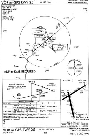
According to the instrument approach procedure, the ILS RWY 18 approach
frequency at Lebanon was 111.9 mhz.
At 0939:40, the first officer called for the approach checklist, and the
captain responded with the approach items, followed by, "okay, approach set
up is
complete." At 0941:28, the captain confirmed with the center controller that
the crew had weather "information hotel" for Lebanon. At 0945:10, the crew
was
instructed to maintain a heading of 050 degrees magnetic, and at 0946:06,
they were issued a descent from 7,000 feet to 4,700 feet. At 0946:14, the
controller
stated, "lear eight lima sierra...once you leave five thousand proceed
direct BURGR for the i-l-s approach," which was acknowledged by the captain.
According to the radar data, the airplane was about 1 nautical mile
southwest of the Lebanon VOR, heading northeast, at that time.
The Lebanon VOR was located 066 degrees magnetic, 4.4 nautical miles from
the approach end of Runway 25 at Lebanon Airport. According to the ILS RWY
18 approach procedure, BURGR intersection was identified as an outer marker
on the localizer, and was also 6 nautical miles from the Lebanon VOR, on its
317-degree radial.
At 0947:21, the airplane was about 3 nautical miles northeast of the Lebanon
VOR, descending through 5,500 feet. About that time, the center controller
radioed: "and eight eight lima sierra, maintain four thousand seven hundred
until established on a portion of the approach, cleared i-l-s approach
Lebanon."
The captain acknowledged both the altitude and the approach clearance, and
shortly thereafter, the crew configured the airplane to "flaps eight."
According to the radar data, the airplane continued to the northeast, until
the last outbound radar contact, at 0947:45. At the time, the airplane was
at 4,900
feet.
At 0948:35, the controller told the crew that radar service was terminated,
and to contact Lebanon Tower.
At 0948:52, the captain contacted the Lebanon Tower controller, and
reported, "...with you i-l-s one eight inbound, seven out outside of BURGR."
The tower
controller then reported that, "weather remains basically the same. winds
are one niner zero at seven now. altimeter two niner eight three." The
captain
acknowledged the call, then asked if the airplane was cleared to land. The
tower controller told him to report BURGR inbound.
At 0948:57, radar contact was regained, northwest of the last contact,
consistent with the airplane having made a left, teardrop turn. Subsequent
radar
returns indicated that the airplane then headed southwest. At 0949:57, the
airplane was at 4,700 feet, and about 11 nautical miles northeast of Lebanon
Airport.
At 0949:58, the captain stated to the first officer, "well, I was looking at
the ah airport thinking that it was eight miles." The first officer then
discussed
the amount of flaps deployed, and the captain asked, "you want 'em up?" The
first officer said that he did, and right after, at 0950:17, the captain
said,
"four thousand seven hundred...." Shortly thereafter, he said, "let's get
some speed up here."
At 0950:41, the first officer stated, "okay, localizer's coming alive,"
then, "localizer's alive."
At 0950:55, the captain stated to the first officer, "what's up with
this...," and the first officer then asked, at 0951:16, "tuned and
identified, right?" The
captain did not answer the question, but at 0951:20, said, "we're not
getting a localizer here." At 0951:21, the captain reported to the tower,
"...we're BURGR
inbound we're not getting a localizer."
Radar data revealed that the airplane was not at BURGR at that time, but was
about 5 nautical miles to the southeast of it, heading southwest.
At 0951:29, the tower controller asked if the crew was going to continue the
approach or execute a missed approach from that position, and reported that
the
localizer was "in the green." The captain answered back, "roger." The
captain then told the first officer to descend to 3,500 feet. The first
officer asked for flaps eight, and the captain answered, "going to eight."
At 0952:07, the captain stated, "all right, we've missed, execute missed
approach," to which the first officer responded, "okay."
At 0952:09, the tower controller asked for the crew's intentions. The
captain responded that they were going to execute the missed approach, and,
"we're not
receiving the localizer." Six seconds later, at 0952:18, the controller
said, "roger."
The published missed approach for the ILS RWY 18 approach was: "Climb to
2000', then climbing RIGHT turn to 4800' direct IVV NDB and hold." The IVV
NDB was the White River NDB, which was located about 8 nautical miles
southwest of the Lebanon Airport, with a frequency of 379 khz.
At 0952:20, the captain said to the first officer, "missed approach," then
told him to "climb to two thousand turn forty eight hundred, direct to the
n-d-b."
The first officer responded, "all right", and the captain then said, "set
three seventy nine, I'll put that in there." At 0952:28, the tower
controller told the crew to execute the "...published missed approach,
contact Boston Center...."
According to the radar data, at that time, the airplane was about 2 nautical
miles southeast of the VOR, proceeding southeast, at approximately 4,500
feet.
At 0952:36, the first officer called for "flaps up," and the captain
responded with, "flaps up." The first officer then asked, "what's the
altitude you want me to go to," to which, the captain first answered, "just
climb," then said right after that, "forty seven hundred." At 0952:50, the
captain reported to Boston Center that the airplane was "on the missed." The
center controller asked for the crew's intentions, and the captain responded
with a request for a confirmation that the localizer frequency was 111.9 mhz.
The center controller told the captain that he'd check on it, but to fly the
"published missed procedure," and maintain 5,000 feet. At 0953:24, the
captain acknowledged the instructions to fly the published missed approach
procedure at 5,000 feet.
According to the radar data, the airplane climbed to 5,000 feet shortly
after being cleared to that altitude. However, it did not make a turn to the
right, to
proceed to the White River NDB, per the published missed approach
instructions. Instead, it continued heading to the southeast.
At 0953:27, the first officer stated, "this ah this ah I'm not even getting
an a-d-f." Seven seconds later, the captain responded with, "here you go."
At 0953:35, the center controller confirmed that the localizer frequency had
been 111.9 mhz, and the captain reiterated that the crew was unable to
receive it. At 0953:50, the captain requested the VOR RWY 25 approach with
"circle to land." The controller approved the request, and then, at 0954:19,
cleared the airplane to proceed directly to the VOR.
According to the radar data, at that time, the airplane was about 9 nautical
miles southeast of the Lebanon VOR. The airplane made a right turn from that
position, and headed back toward the northwest.
According to the VOR or GPS RWY 25 approach procedure in effect at the time,
the outbound course from the VOR was 066 degrees magnetic, with a descent
down to a minimum of 4,300 feet above mean sea level. The procedure turn was
to be completed within 10 nautical miles of the VOR. The published course
reversal for the procedure turn included an initial left turn to a heading
of 021 degrees magnetic, followed by a right turn to a heading of 201
degrees magnetic, until joining an inbound course to the VOR of 246 degrees
magnetic. After joining the inbound course, the approach called for a
descent to a minimum of 2,900 feet, until the Hanover NDB/marker beacon,
which was on the inbound course, 2.2 nautical miles northeast of the VOR.
Upon reaching Hanover, a descent to a
minimum of 2,300 feet was authorized, until after passing the VOR. At that
time, a descent to the published minimum descent altitude could be made. The
Lebanon VOR operating frequency was 113.7 mhz and the Hanover NDB operating
frequency was 276 khz.
At 0954:24, the captain stated to the first officer, "well let me set you up
here. same thing lebanon. three oh four." At 0955:07, the airplane was
cleared to cross the Lebanon VOR at or above 4,700 feet, then cleared for
the VOR RWY 25 approach. At 0955:19, the captain stated, "three fourteen."
The first officer
responded with, "no problem.... I'm gonna go outbound on the zero six six
radial and...here." At 0955:52, the captain stated: "three one eight," then
repeated it
twice more. At 0956:04, the captain stated, "let me get rid of this thing,"
and shortly thereafter, stated, "it'll probably make things easier for you."
At 0956:16, the captain said, "I'll take our time outbound," and at 0957:08,
stated, "okay that's gonna be our outbound zero zero six. Go off
Lebanon."
At 0957:43, the center controller stated, "...radar service is terminated
contact Lebanon tower now one two five point niner five." The captain
rogered, and contacted Lebanon Tower, "on the v-o-r two five circle to land
one eight." The tower controller then requested the airplane's
position, and at 0958:07, the
captain answered back, "...we're ah five miles to the ah southeast of the
v-o-r."
According to the radar data, when the captain called the 5 miles, the
airplane was about 5 nautical miles to the southeast of the VOR.
The tower controller then told the crew to report "v-o-r outbound." He also
stated, "...I'll give you a wind check ah in the vicinity of the v-o-r
inbound.
Winds are currently two three zero at five...." He then gave them the option
to land on Runway 25 instead of Runway 18, which they accepted.
At 0958:41, the first officer called, "over station passage." However, at
that time, the airplane was about 2 nautical miles south of the Lebanon VOR,
inbound.
The captain immediately responded with, "yeah...this is the airport that's
the v-o-r. they're not on the field." The first officer responded with, "oh,
I see," and the captain continued with: "...just to let you know."
At 0958:47, the first officer stated, "I might as well start turning now,"
and 1 second later, asked: "zero zero six?" At 0959:39, the captain stated,
"all right now, inbound heading is two forty six. keep...on the turn." At
0959:46, the first officer asked, "two forty six?" and the captain
responded, "the inbound. remember we've got to go outbound." The first
officer then said, "yeah." At 0959:52, the captain called, "okay,
station passage, time is set."
According to the radar data, when the captain called station passage, the
airplane had just passed over the VOR.
At 0959:55, the captain reported, over the radio, "...v-o-r outbound," and
the controller requested that they report the VOR inbound. The first officer
then asked the captain, "down to what alt?", and the captain responded, at
1000:04, with "zero six six outbound..." At 1000:09, the first officer said,
"okay and ah," but the captain cut in at 1000:10 with, "let's go zero six
six. grab it. let's go," and the first officer responded with, "zero
six six."
At 1000:17, the tower controller transmitted, "go ahead maintenance." At
1000:19, the first officer asked, "altitude?", and the captain responded,
"four thousand seven hundred. At 1000:27, the tower controller transmitted,
over the radio, "maintenance roger." The captain commented to the first
officer, "well they're fixing the i-l-s," and the first officer responded,
"you bet your...."
At 1000:42, the first officer said: "okay time it," and the captain
answered, "okay...let's just track back. we have plenty of time. let's just
intercept that." Seventeen seconds later, the captain said, "take a big cut
into that." At 1001:19, the captain stated, "needle's coming alive." The
first officer acknowledged, then the captain stated, "go to a heading of two
two one." He repeated the heading of "two two one" 12 seconds later, and
told the first officer to "get it around." At 1001:49, the first officer
stated, "two two one altitude?" At 1001:53, the captain said, "no, zero two
one. zero two one for one minute," to which, the first officer acknowledged.
Elapsed time between the captain calling station passage, and his calling
out the corrected course reversal heading, was about 2 minutes.
The last recorded radar data for the flight, at 1001:47, indicated that the
airplane was about 7 nautical miles northeast of the Lebanon VOR, at 4,800
feet. The average groundspeed outbound was about 230 knots, and the
airplane was proceeding along an east, northeasterly ground track.
At 1002:04, the captain stated, to the first officer, "...we stay at this
altitude until we intercept. then we go down to twenty nine hundred." This
was followed at 1002:10, by the captain saying, "we can go down to twenty
nine now."
At 1002:17, the first officer asked, "right turn or left turn to ah two two
one?" At 1002:19, the captain told him it would be a right turn. At 1002:23,
the captain said, "two forty six on that...you go to two oh one," which the
first officer acknowledged. At 1002:26, the captain stated, "okay and
intercept that." The first officer then asked, "and make a right
turn in to intercept?" The captain confirmed, "a right turn," and at
1002:32, the first officer stated, "oh okay."
The elapsed time between the captain calling station passage, and the first
officer's last acknowledgment of the right turn to 221 degrees, was 2
minutes, 40 seconds.
At 1002:38, the captain stated, "...approach flaps." At 1002:40, the first
officer said, "let me know ah time," and the captain responded with, "'kay
you got about fifteen seconds."
At 1002:56, the first officer stated, "twenty nine," and at 1003:06, the
captain stated, "okay let's turn. maintain three thousand. let's maintain
three." The first officer acknowledged the three thousand feet, then, at
1003:15, the captain said, "let's put thirty degrees of bank in
there...intercept." The first officer said, "oh yeah," then asked for
approach flaps. The captain responded with, "speed checked. approach flaps."
At 1003:35, the captain told the first officer to "put thirty degrees of
bank in there," then, 12 seconds later, said, "thirty degrees of bank to
intercept." At 1004:18, the captain stated, "okay it's alive. keep it
going," and the first officer responded with, "coming around," and shortly
thereafter, asked, "down to what altitude?" The captain responded with, "kay,
we'll just intercept that first...."
At 1004:46, the captain stated, "there's the outer marker right there. do
you have it?" The first officer responded, "yeah." Then, at 1004:49, the
captain stated, "okay, we can go down to twenty three."
At 1004:54, the first officer stated, "the v-o-r doesn't want to...see
that?" At 1005:07, he asked, "see the v-o-r?" At 1005:12, he said, "oh
i guess," followed, at 1005:17, by, "the v-o-r's out."
At 1005:18, the captain responded with, "well there's the v-o-r right
there," and the first officer answered, at 1005:20, with, "yeah, but it's
all over the place."
At 1005:22, the captain stated, "let's get deflection...," and at 1005:25,
the first officer stated, "going down to twenty three."
At 1005:28, a sound of static began on the CVR. It ended at 1005:30.
At 1010:06, the tower controller radioed the crew for the airplane's
position, then tried again, 23 seconds later. When no reply was heard, the
tower controller contacted a number of aircraft, as well as other air
traffic control facilities, in an attempt to communicate with the airplane.
On the morning of November 11, 1999, the wreckage was discovered on private
property by a forester. He reported the discovery to the owner of the
property,
who in turn, notified a brother of one of the pilots. The following day, the
property owner and the forester escorted the brother, and a friend of the
brother, to the site. Later that afternoon, they informed New Hampshire Fish
and Game Department officials of the discovery.
The accident occurred during the hours of daylight, and the wreckage was
located at 43 degrees, 49.56 minutes north latitude, 72 degrees, 00.75
minutes west
longitude.
CREW INFORMATION
The captain held an airline transport pilot certificate with a rating for
airplane multiengine land, commercial certificate with a rating for airplane
single engine land, and was a certificated flight instructor with ratings
for airplane single and multiengine land, and instrument airplane. He was
also type-rated in the Learjet. His most recent Federal Aviation
Administration (FAA) first class medical certificate was issued on November
1, 1996, with no limitations.
According to company records, as of December 21, 1996, the captain had 4,250
flight hours, of which, 3,658 were as pilot in command, 1,820 were in
multiengine airplanes, and 832 were in turbojets. He also had 186 hours of
actual instrument time, and 25 hours of simulated instrument time. His last
flight prior to the accident flight was on December 21, 1996, when he flew
9.7 hours in the accident airplane.
According to FAA records, the captain received his private pilot
certification, single engine land airplanes, on March 16, 1990. On May 4,
1990, he failed the
flight, oral and practical portions of his examination for an instrument
rating, and was notified he would be reexamined in "all pilot operations."
On May 11, 1990, he successfully completed the reexamination for his
instrument rating. On June 29, 1990, he failed the flight portion for his
commercial certificate; "pilot operations 4,5,6,9 [and] lazy eights were
unsatisfactory." On June 30, 1990, he successfully completed his
reexamination, and was issued a commercial certificate for single engine
land airplanes and instrument-airplane.
On September 12, 1990, the captain failed the practical portion for a
certified flight instructor (CFI) certification, but then passed his
reexamination, and received his CFI certification on October 25, 1990. On
January 5, 1992, he successfully completed the requirements for an airplane
multiengine land rating. On August 19, 1994, the captain failed the
practical portion for his examination for his airline transport pilot
rating. Areas for reexamination were: "Powerplant Failure-Multiengine
Aircraft," "ILS/MLS Instrument Approach Procedures," and "Landing in
Sequence from an ILS/MLS Approach." On August 20, 1994, the captain
successfully passed his reexamination, and was issued an airline transport
pilot rating for multiengine land airplanes. On November 29, 1996, he was
issued a Learjet type rating.
Company training records indicated that the captain received "PIC/Initial
New Hire" training for the Piper PA-31-310 in July 1995. He also received
"Initial
Equipment" training in the Learjet 35 at that time. Among the training
provided, he received "crew resources management." He also received
"differences" training
in August 1995 for the Learjet 20-30 and the Piper PA-31-310. He was
approved for second-in-command duties in the Learjet 35 on August 14, 1995.
The captain also received "Part 135" training in the Learjet 35/36 at Flight
Safety International, and a "FAR 135.293" second-in-command check on October
25, 1995. He successfully completed upgrade training for pilot in
command, in the Learjet 35A, in November 1996, and successfully completed a
"FAR Part 135" airman competency/proficiency check with an FAA inspector on
November 29, 1996. On December 7, 1996, the captain was designated by the
company as its chief pilot.
According to additional company records provided to the Safety Board, in
December 1996, the captain flew 13 flights in the accident airplane. The
additional information listed the captain as pilot in command during 11 of
those flights. During 7 of those 11 flights, the captain flew as pilot in
command with the airplane's part-owner, and on 1 of those flights, he flew
with the company's former chief pilot. The accident flight was the only one
in the accident airplane, in which the captain and the accident-flight first
officer flew together.
The first officer held an airline transport pilot certificate with a rating
for airplane - multiengine land, a commercial certificate with a rating for
airplane - single engine land, and was a certificated flight instructor with
a rating for airplane - single engine land. His most recent FAA first class
medical certificate was issued on August 8, 1996, with no limitations.
According to company records, as of December 23, 1996, the first officer had
2,067 total flight hours, of which, 1,582 were as pilot in command, 997 were
in multiengine airplanes, and 268 were in turbojets. He also had 120 hours
of actual instrument time, and 25 hours of simulated instrument time. His
last flight before the accident flight was on December 23, 1996, when he
flew 0.8 hours in the accident airplane.
According to FAA records, on February 8, 1990, the first officer received
his private pilot certification in single engine land airplanes. On January
17, 1991, the first officer failed the flight portion of his instrument
rating examination. The disapproval stated that he would be reexamined on
"pilot operations 2, area departure and holding." On January 22, 1991, he
successfully completed the reexamination for his instrument rating. On June
19, 1991, he successfully completed his commercial pilot certification for
single engine airplanes and instrument-airplane. On June 21, 1991, the first
officer failed the oral portion for his multi-engine rating. On June 23,
1991, he successfully completed the examination for that rating.
On August 29, 1992, the first officer failed the practical examination for
certified flight instructor (CFI). On October 24, 1992, he failed practical
test once again, with the same examiner. On April 9, 1993, he passed the
test, and was issued a CFI certificate. On October 19, 1995, the first
officer failed his initial practical test evaluation for airline transport
pilot certification. The inspector who gave him the test stated that the
pilot was 30 degrees off course heading inbound on an NDB approach, then
"decided to set the DG [directional gyro] to the inbound course heading." On
the disapproval, the inspector wrote that the reexamination would be on NDB
approach and single engine approach; all other areas satisfactory. On
October 21, 1995, the first officer passed the reexamination.
Company training records indicated that the first officer received initial
company training in February 1996, for the Beech BE-58. He received initial
differences training for the Learjet 25 and Learjet 35 in August 1996. On
August 22, 1996, he was "approved" for second-in-command duties, during a
"FAR 135 Airman Competency/Proficiency Check."
METEOROLOGICAL INFORMATION
At 1636, the day before the flight, the captain called for a preflight
weather briefing, and filed an instrument flight rules flight plan for the
airplane from Bridgeport to Lebanon. He also filed a second instrument
flight rules flight plan from Lebanon to The Francis S. Gabreski Airport (FOK),
Westhampton Beach, New York, and then filed a visual rules flight plan from
Gabreski to Bridgeport. At 2037, the evening before the flight, he obtained
an outlook weather briefing for the flight, and at 0849, on the day of the
accident, he obtained an updated weather briefing for the flight.
Lebanon Municipal Airport was located about 600 feet above sea level. The
weather, recorded at 0945, included winds from 190 degrees at 5 knots, an
overcast cloud layer at 1,200 feet above ground level (agl), a visibility of
5 statute miles with mist, a temperature 41 degrees Fahrenheit, dewpoint 38
degrees Fahrenheit, altimeter 29.83.
An FAA computer printout, which resulted from the 0849 briefing, had on it,
the latest area winds aloft, at 6,000 feet above mean sea level, as being
from 220
degrees, in excess of 40 knots. In the briefing audio tapes provided by the
FAA, the captain had not requested winds aloft, nor had they been provided.
The captain of a Mesa Airlines flight, which was in holding while waiting
for the accident airplane to land, stated that he might have gotten a trace
of icing during the holding, at 6,000 feet. He noticed a "strong" tailwind
from the southwest at altitude, and was "just in the tops" of the clouds
while in holding. He also noticed some breaks in the clouds "through descent
to DH."
The captain of a Business Express flight, which was about 5 miles to the
south of Lebanon around the time of the accident, also remembered seeing
breaks in the
cloud layers.
AIDS TO NAVIGATION
The localizer facility for the ILS RWY 18 approach was located just beyond
the departure end of that runway. BURGR intersection, which was the initial
approach fix for the ILS RWY 18 approach, was directly over a marker beacon.
The VOR for the VOR RWY 24 approach was located 066 degrees magnetic, 4.4
nautical miles from the runway. A marker beacon for that approach,
co-located with the Hanover NDB, was 066 degrees magnetic, 6.6 nautical
miles from the runway.
A chronology of events was provided with an air traffic facilities package
from the FAA. The times listed in the chronology were in Greenwich Mean Time
(Z). The accident occurred at 1005 Eastern Standard time, which equated to
1505Z. Events included:
On December 25, 1996, at 0055:
"Ground evaluations and certification of Lebanon NH runway 18 LOC, GS. MM,
OM VOR/DME, MCR and 125.95 mhz radio equipment is complete. Ground
evaluations and certification of Cummington MA ARSR, ATCRB and CD equipment
is complete. Evaluation and certification of ARTCC facilities and
service at Nashua NH are complete. All facilities were found to be operating
satisfactorily."
On December 26, 1996, at 0126:
"LEB VOR/DME failed due to a crushed cable caused by ice buildup in a cable
duct."
On December 26, 1996, at 1730:
"FAA flight check completed on Lebanon NH runway 18 LOC, GS, MM, OM and IVV
NDB. All were found to be satisfactory. The VOR/DME were not flight
checked because the facility was off the air due to the continuing repair
activity."
On December 27, 1996:
"Ground evaluation of LAH NDB was conducted. This New Hampshire state
operated facility was found to have modulation out of tolerance 66 percent
versus 80 to 95 percent. Facility was left as found."
On January 3, 1997:
"Lebanon NH VOR/DME is repaired and ready for flight check."
On January 6, 1997:
"Lebanon NH VOR/DME and LAH NDB were flight checked and found to be
satisfactory. Lebanon VOR/DME returned to service, modulation level of LAH
NDB was adjusted into tolerance by state technician."
Transmissions between Boston Center and Lebanon Tower included:
At 0952:45, the tower controller reported to the center controller that,
"...the Learjet is coming back to you, published missed, ah, lost the
localizer. we're showing it in the green and I'm going to have a technician
go out and check it just in case."
After several other calls, the center controller reported, at 1007:04, "air
shuttle fifty three thirty two [Mesa Airlines] is gonna go out and try the i-l-s.
He picked it up okay. You still getting a good signal on it?" The tower
controller responded with, "ya, we had maintenance check it out and there's
no problem, so at least that's what they're saying."
The captain of the Mesa Airlines flight which landed shortly after the
accident airplane was lost, stated that there were "no problems with [the]
ILS" during his approach.
During the accident captain's first weather briefing, the briefer reported
that the Lebanon VOR was out of service. During his final briefing, the
captain asked if the VOR was still out of service, and the briefer reported,
"I don't even show that one, unless its something's that's published.
I don't have anything for Lebanon this morning."
AIRCRAFT INFORMATION
According to the operator's records, the airplane had been on a continuous
inspection program, with 6,897 total airframe hours. The left engine had
6,767 hours of total time, 1,090 hours since overhaul, and 143 hours since
its last inspection. The right engine had 6,897 hours of total time, 1,563
hours since overhaul, and 67 hours since its last inspection.
WRECKAGE AND IMPACT INFORMATION
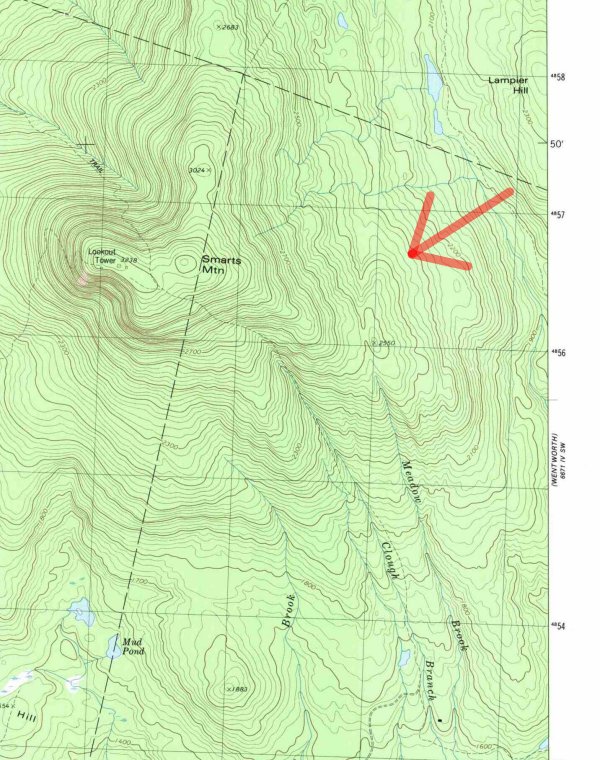
The wreckage was located approximately 17 nautical miles, 063 degrees
magnetic, from Lebanon Municipal Airport. It was on rising terrain, about
2,300 feet above sea level, on the northeastern side of one of the foothills
of Smarts Mountain. It was in a forested area, and parts of the
wreckage were partially covered with fallen tree debris from an earlier ice
storm.
Many trees in the area had been fractured near their tops due to the ice
storm. However, a path of sheared trees was found, with a debris trail
alongside, that led to main fuselage. The path began about 360 feet prior to
wreckage, and proceeded along a 229-degree magnetic heading, at a varying 3-
to 5-degree descent angle. The descent path terminated near the bases of
two, 1-foot diameter trees which had been uprooted, and pushed over. The
main fuselage was found about 60 feet beyond, and upslope of those trees,
with only the right engine still attached.
The front of the main fuselage and a nearby tree exhibited fire damage. The
left engine was found to the right of the main wreckage. The cockpit area
had been
destroyed. The engine instruments that were found indicated a turbine speed
of 62.2 percent for the left engine, and 62.1 per cent for the right engine,
a fan speed of 41.3 percent for the left engine, and 49.6 per cent for the
right engine, and indicated temperatures of 434 degrees for the left engine,
and 485 degrees for the right engine. There was no evidence of catastrophic
engine failure or fire.
On the left side instrument panel, the HSI was on "MAG", the course selector
was on 246 degrees, the heading bug was on 218 degrees, and the indicated
heading was approximately 225 degrees. The vertical speed indicator was on
zero, the DME was digital, and the remaining instruments were either broken
or missing.
On November 17, 1999, after the wreckage had been removed, an individual at
the site found the control heads to the VOR navigation system. The
individual
notified the Safety Board, and reported that the number 1 VOR navigation
head was on 113.65 mhz, and the number 2 VOR navigation head was on 113.70
MHz. The individual forwarded the heads to the Board in October 2000. The
gearing behind the number 1 head, which selected the frequency, was found to
be twisted and out of alignment, and exhibited impact damage.
The accident site was located about 061 degrees magnetic, 12.5 nautical
miles from the Lebanon VOR.
ADDITIONAL INFORMATION
---Approach Briefing---
According to the company's operations manual:
"Prior to commencing any approach, all pilots will review all information
available relative to the approach, landing, and missed approach procedures.
The
airspeed at which the final approach will be made shall be specified by the
Pilot in Command consistent with existing conditions: gross weight, wind
conditions, etc. All pilots should be aware of the approximate rate of
descent during the approach, and a descent rate which must necessarily
exceed normal parameters should be discussed.
For two-pilot crews during instrument approaches, normally the pilot flying
briefs the pilot not flying on data pertinent to the approach, to include at
least: final approach course, altitude to the final approach segment, MDA or
DH (both radar and barometric, when available), field elevation, missed
approach procedures, and any special requirements or conditions. For
non-precision instrument approaches without a specified VDP, a "time to see"
point should be calculated for straight-in approaches to promote awareness
of the position of the aircraft relative to a normal approach angle. If a
circling approach in instrument conditions is contemplated, the approach
briefing should include the detailed plan for executing the circle. The
pilot not flying should add or amend any significant information items that
may have been omitted or are erroneous."
---Crew Coordination During Approach - Two-Pilot Crews---
According to the company's operations manual:
"Company S.O.P. (Standard Operating Procedures) will be strictly adhered to
on all approaches. It is important for all flight crewmembers to understand
the
proposed plan of action for all phases of flight, but this shared plan
awareness is especially critical in the approach and landing phases. When
traffic, weather, or other considerations dictate any deviations from the
S.O.P., or necessitate additional crew coordination activities, these items
will be thoroughly briefed in the approach briefing.
The overriding considerations during the approach and landing phases are
that a stabilized approach will be flown at least during the final approach
segment, and that all flight crewmembers are aware of the details of the
final approach and missed approach segments. If, for any reason, the
aircraft is not configured for a stabilized final approach segment, or
flight crewmembers have not sufficiently reviewed all the pertinent
information for the approach and missed approach, the crew will request
delaying procedures, such as additional turns in a holding pattern or radar
vectors back to final, to allow the final approach segment to be initiated
in a stabilized and prepared fashion. In addition, if, for any reason, the
aircraft cannot continue to be stabilized on the final approach segment, a
missed approach will be initiated rather than attempting to 'save' the
approach."
---Nonprecision Instrument Approaches---
According to the company's operations manual, nonprecision approaches were
flown as follows:
Approaching the initial approach fix (IAF): gear and flaps up, airspeed Vref
plus 40 knots, approach checklist complete.
IAF outbound: flaps 8 degrees, airspeed Vref plus 30 knots, descend if
required.
On course inbound: flaps 20 degrees, gear down, airspeed Vref plus 20 knots,
before landing checklist, complete to flaps 40 degrees.
Final approach fix: flaps 40 degrees, airspeed Vref minimum.
---Area Navigation---
According to the company's FAA-approved operations specifications, the
company was authorized to use a Trimble TNL2101 GPS in the accident
airplane. However, in the "installation description of work accomplished,"
there was the statement, "The panel has been placarded 'GPS LIMITED TO VFR
USE ONLY'."
According to the manufacturer's equipment list, the airplane was equipped
with a Global GNS-500-3A VLF/Omega.
According to air traffic control transmissions, the airplane was initially
cleared direct to BURGR intersection, for the ILS RWY 18 approach.
In the flight plan, the airplane's equipment code was listed as "/R".
According to the Airman's Information Manual, "/R" signified "RNAV and
transponder with
altitude encoding capability."
---Distance Measuring Equipment---
According to the manufacturer's equipment list, the airplane was equipped
with a Collins DME-40.
Other than when an air traffic controller asked the crew the airplane's
distance from the Lebanon VOR, there were no additional discussions of
distances on the
CVR transcript.
---ADF Operations---
According to the manufacturer's equipment list, the ADF installed on the
accident airplane was a Collins ADF-60. Excerpts from the Collins Operations
Manual included:
Under general operations: "The ADF-60 system provides aural reception of
transmissions from a selected ground station and indicates relative bearing
to that station. The ground station must be within the operating range of
190 to 1,749.5 kHz."
Under "Frequency Selection": "Tune the ADF control unit until desired
frequency is indicated in control unit display window and verify the station
identifier."
Under "ADF Function": "Set ADF control unit function switch to ADF. The RMI
pointer will indicate relative bearing to the tuned station. Adjust the
volume as required." A note under the same heading stated: "When the ADF-60
system is not receiving a reliable signal, the RMI pointer will remain
parked in ADF mode.
The ADF-60 may momentarily park during station crossings because of signal
loss."
---Navaid Identification---
There were no sounds of navigational aid identification, on the CVR
recording.
---Unidentified Clicks---
According to the CVR Group Chairman's Factual Report, the CVR contained
audio information on three of the four audio channels. "Unidentified clicks"
were
recorded only on the cockpit area microphone (CAM) channel.
According to the CVR Specialist's Waveform Study, audio heard on a CVR
recording would usually fall into two source categories. One source, would
be audio
acoustically recorded via the CAM or pilot headset microphone, and normally
found on only one CVR channel. The other source would be electrical noise or
interference, introduced into, and recorded by the CVR system.
Electrically-induced disturbances would normally affect the entire CVR
system, and the resulting spikes or noises would be found on more than one
CVR channel.
The Study further reported that most acoustic click sounds found on CVR
recordings contained characteristics similar to a "classic" impulse
response. A classic impulse response was defined as a sound or signal with a
short duration that resulted in a spike in amplitude, with an even energy
distribution across the entire frequency band. The majority of the clicks
found in the accident CVR study were consistent with the characteristics of
an acoustic impulse sound.
The Study also noted that the identification of the exact source of an
impulse noise, like a click, would not usually be possible.
---Wreckage Release---
On November 13, 1999, the airplane was released to a representative from
United States Aviation Underwriters (USAIG), New York, New York.
See also the NTSB SUMMARY, PROBABLE CAUSE PDF, and FULL NARRATIVE
See also the investigation FINAL REPORT, copied from the now-defunct "Missing Learjet" web site
See also local media descriptions - Dartmouth Medical and South Coast Today: 1, 2, 3
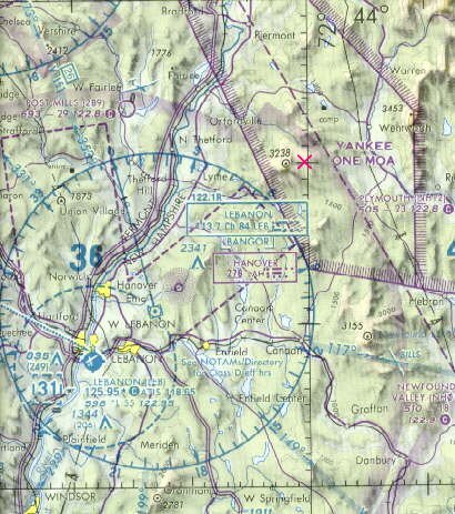
This is a map from the now-defunct "Missing Learjet" website that shows the last
known position. I added an "X" approximately where the plane was
eventually found. There were 40-60 knot winds at 4000' from the southwest
that day.
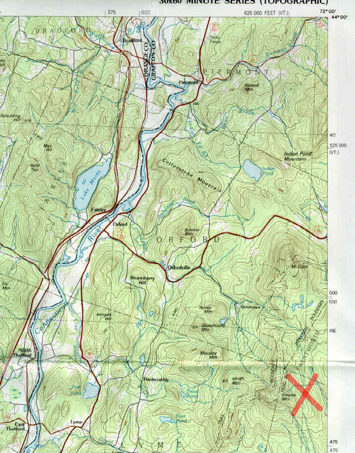
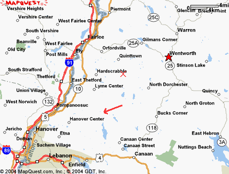 This map shows the same 2 approximate points, with town names. The
topo maps below show that the crash was at the corner of 4 towns; Wentworth,
Dorchester, Lyme, and Orford, with the actual site being just barely into
Dorchester:
This map shows the same 2 approximate points, with town names. The
topo maps below show that the crash was at the corner of 4 towns; Wentworth,
Dorchester, Lyme, and Orford, with the actual site being just barely into
Dorchester:
In 2002 or 2003, I went to a very well attended (standing-room-only) presentation by the FAA at KLEB, covering in minute-by-minute detail everything that occurred between the time the plane came to the Lebanon area and the time contact was lost. It was quite interesting. Many local people spent a lot of time trying to find the missing plane.
For more info on this, see the wikipedia entry for it
For more local info, see my LOCAL page.
BACK TO MY RV BUILDER'S HOME
BACK TO BRIAN'S HOME